Dual-Polarization Observations and Simulations of Tornadoes
Tornado debris signatures (TDSs) are dual-polarization signatures of lofted debris in tornadoes. Our past research has shown that TDSs can be used to obtain estimates of near real-time damage severity, and operational forecasters use these signatures to detect and characterize damaging tornadoes (Bodine et al. 2013, 2014). In our recent work, we have used high-resolution data from PX-1000, OU-PRIME and RaXPol to quantify the relationship between TDSs and kinematic characteristics of tornadoes (Kurdzo et al. 2015; Griffin et al. 2017, 2020; Wakimoto et al. 2020).
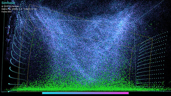
To investigate TDSs further, we are using high-resolution mobile radar data and a radar simulator called SimRadar (Cheong et al. 2017). SimRadar combines high-resolution data from a Large-Eddy Simulation model, aerodynamic data from wind tunnels, and electromagnetic scattering data to emulate dual-polarization TDSs. These data allow us to model the motions and orientations of debris in the tornado's intensely varying wind field and how each piece of debris contributes to the observed radar signature. Using SimRadar, we are exploring how differences in the type of debris lofted affect the TDS as well as how different tornado intensities or flow structures (e.g., multiple vortices) affect TDS structure.
Visualization of Simulated Tornado with Debris (click here to see the animation!)
Observations of a TDS: OU-PRIME
Numerical Simulation of a TDS: SimRadar
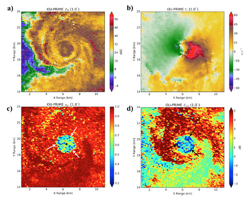
The OU-PRIME 10 May 2010 dataset started my interest in tornado debris signatures (TDSs). We used this data set to explore how TDSs are related to surface damage and dual-wavelength differences in TDSs (Bodine et al. 2013; 2014), as well as the relationship between TDS structure and kinematic characteristics of tornadoes (Griffin et al. 2017). Here, you can see a prominent TDS evident by low ρHV (bottom left) and near-zero or negative Zdr (bottom right).
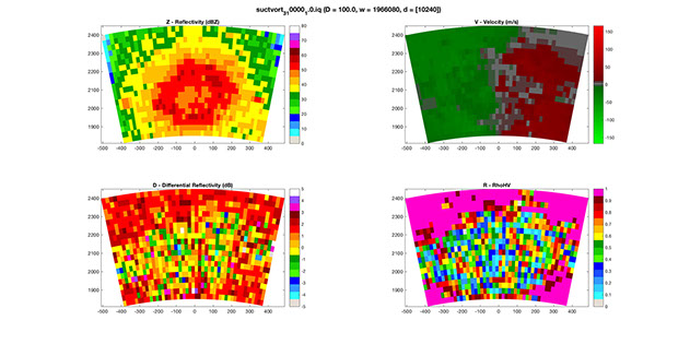
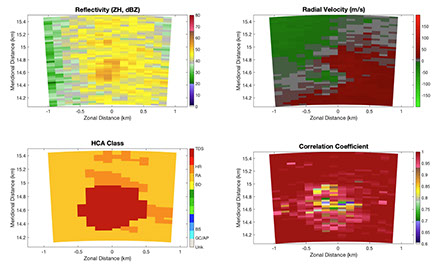
SimRadar produces moment and time series data, and the dual-polarization moment data are shown here. This figure shows an example of polarimetric data from a SimRadar simulation of a TDS from a simulation with wood boards. The top left panel is radar reflectivity factor (Z) and shows a concentric ring of high Z often seen in tornadoes, which surrounds an area of low Z (weak-echo hole). The top right panel shows the Doppler velocity. The bottom left panel shows Zdr or differential reflectivity, which shows near-zero Zdr in the TDS and positive Zdr in areas of rain surrounding it. Finally, the bottom right panel shows co-polar cross-correlation coefficient. Low values of ρHV are indicative of lofted debris and are clearly seen here in the simulation. To learn more about SimRadar, check out our papers:
SimRadar Description and Examples: Cheong et al. (2017)
SimRadar Analyses of Debris Orientation and Dual-Polarization Spectra: Umeyama et al. (2018)
Phased Array Radar Studies Using the Atmospheric Imaging Radar
Between 2011 and 2019, we conducted experiments with the Atmospheric Imaging Radar (AIR; Isom et al. 2013; Kurdzo et al. 2017) each spring to collect rapid-scan observations of severe thunderstorms. The AIR is a mobile phased array radar (PAR) that uses digital beamforming to collect observations simultaneously in a vertical column. Thus, by only mechanically scanning in azimuth, the AIR can collect volume scans every 5 to 10 s without having to steer the beam in the vertical direction.
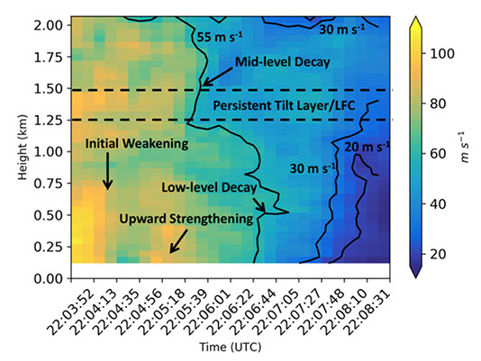
Using this unique system, we collected 46 supercell cases and over 10 tornado cases. We are analyzing these data to study rapidly evolving processes during all phases of the tornado's life cycle, including genesis, intensification, and dissipation. An example of AIR data during tornado dissipation is shown on the right for the 27 May 2015 tornado (Griffin et al. 2019). Dissipation began with a weakening at mid-level (~1.25 to 1.5 km) and then proceeded in a downward fashion. During the final minute or two of the tornado, it remained more intense between 500 and 1000 m compared to below and the tornado fully dissipates first at the surface and then upward in time over ~30 s (around 22:08 UTC).
Using the archive of tornadic and nontornadic supercell cases, we are exploring differences leading to tornado formation or tornadogenesis failure. One of our recent REU students, Kyle Pittman, examined tornadogenesis failure from an AIR case collected near Denver, CO in 2014 (REU Paper).
The AIR is being replaced by a dual-polarization C-band radar called the Polarimetric Atmospheric Imaging Radar (PAIR; Salazar et al. 2019) as well as an S-band dual-polarized PAR called HORUS. We will be using these systems once they are completed to continue studies of severe convective storms using phased array radars.
Time-Height Plot of Delta-V from Griffin et al. (2019) MWR
High-Resolution Simulations of Tornadoes: How Do Terrain and Buildings Impact Tornado Dynamics?
The importance of friction to tornado dynamics has been noted for decades with a seemingly paradoxical result that friction intensifies tornadoes. Yet, it serves as a critical mechanism necessary for generating the tornado's intense corner flow and can allow angular momentum to reach closer to the tornado's central axis than would be possible in its absence.
The surface beneath tornadoes is often modeled or assumed to be homogeneous, yet we know from observations that tornadoes encounter a rich variety of terrain and manmade structures along their paths. To date, few studies have used high-resolution numerical models to understand how terrain or manmade structures impact tornado dynamics and how these resulting changes affect societal risk to tornadoes. Complex terrain is particularly common in the Southeast United States where a rich variety of small mountain ranges, plateaus are present across this often heavily forested region.
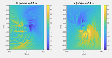
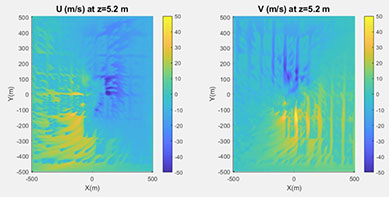
To model the impact of terrain and buildings on tornado dynamics, we use a high-resolution numerical model (Large-Eddy Simulation model) which provides 1 to 2 m horizontal and vertical resolution near the surface. An immersed boundary method (IBM) is used to implement different types of terrain and manmade structures. The IBM applies forces along the boundary surface to impose the proper boundary condition along a non-uniform 2D surface.
Terrain: As part of a VORTEX-SE experiment, we examined the sensitivity of tornado dynamics to terrain by varying the height of the terrain, distance between terrain features, and type of terrain (hill, valley, ridge, etc.). This work was led by M.S. student Martin Satrio and the results are published in the Journal of Atmospheric Sciences (Satrio et al. 2020). Some of the key conclusions from this work include:
- Complex terrain increases the variability of near-surface winds in tornadoes, but by a relatively small magnitude for the horizontal component (<10%)
- Near-surface horizontal wind speeds are highest in valleys and low-lying areas
- Small terrain features are found to slightly enhance near-surface horizontal wind speeds whereas large terrain features become disruptive and reduce near-surface wind speeds
- Terrain increases near-surface vertical motions and increases in terrain height produce larger vertical velocities
Buildings: Considerable variability in damage is often evident in residential areas, which stems from differences in the quality of construction as well as differences in wind and debris loading. The wind and debris loading experienced by one residence depends on how the near-surface winds are modified by nearby structures as well as what debris is generated. To better understand tornadoes interacting with residential areas, we started a new VORTEX-SE project aimed at understanding how 1) the geometry of residences and residential areas impacts the tornado's three-dimensional wind structure, and 2) what wind and debris forces impinge upon residential structures. The study will also model the damage process to emulate observed damage paths, and the simulations will be compared to tornadoes in the Southeast US.
3D Visualization of a Simulated Tornado Traversing 100-m Tall Hills
Simulated tornado traversing the track of the 22 May 2011 Joplin, MO EF-5 Tornado
Understanding the Benefits and Limitations of a Future Operational Phased Array Radar Network
Phased array radars (PARs) offer significant potential to improve operational forecasting capabilities by improving temporal resolution from 5 min with NEXRAD to 1 min or less with a PAR and providing adaptive scanning capabilities to prioritize regions of interest. Thus, PARs are considered a strong candidate to replace the existant NEXRAD radar network, which is nearing its lifespan. Many challenges remain to implementing a PAR network across the United States, and our research is focused on addressing some of these needs.
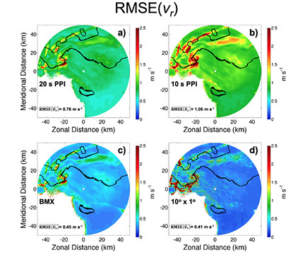
One specific area of interest is determining what phased array scanning techniques can be used to improve temporal resolution without degrading data quality. In collaboration with Prof. Tian-You Yu and Dr. Andrew Mahre, we are using radar simulators to understand the scientific benefits of rapid-scan observations for mesocyclone and tornado detection and characterization. We are also quantifying the tradeoffs between different phased array scanning techniques, such as contiguous pulse sampling, beam multiplexing, and digital beamforming. Finally, we are collaborating with Prof. Xuguang Wang's research group on data assimilation experiments with a future PAR, including improvements possible from assimilating clear-air wind data discussed in our recent paper in WAF (Huang et al. 2020).
In collaboration with Prof. Robert Palmer and Caleb Fulton, we are examining how very low cost, passive radars can be used to retrieve rapid-scan, three-dimensional winds using a future PAR network. A prototype passive radar was developed by Prof. Palmer and Fulton's student, Andrew Byrd, and results are shown in a recent IEEE paper. These passive radars can collect the scattered signal from Doppler radars, but at a different viewing angle than the transmitting radar. Thus, a different component of the wind field is sampled. In the future, networks of passive radars could be deployed to provide high-temporal resolution, 3D winds across the country, which could greatly improve:
- The detection of strong and intensifying inflow and updrafts that precede many severe hazards
- The characterization of storm-scale flow features critical to tornadogenesis and their evolution, such as the rear-flank downdrafts and associated momentum surges
- The detection of strong straight-line winds, often missed when winds are oriented across the radar beam
Simulated Development of a TDS from a Scanning PAR
Differences in Doppler Velocity Data Quality for Different PAR Scans
